

Create powerful, fast, customized 3D images of your data with Voxler 2. Easily import data in a multitude of file formats to create stunning graphics to explore the relationships in your data set. This robust, yet easy-to-use program gives you the power to display your data in a variety of formats and colors, capture video animation of your moving model, and select from several image and data export options.
Features
What's New in Voxler 2?
Voxler 2 —Unleash Your 3D Potential
Import Vector Formats:
New import options include popular BLN, DDF, DLG, DXF, E00, GSB, GSI, MIF, SDTS, and SHP vector format files, giving you increased options to explore and generate data-rich images.
Combine 3D drill holes, topography, and isosurfaces on a dramatic black background
to outline an ore body in a mining area using an imported DXF file.
Capture Video Animation:
Create an AVI file to share your 3D models using Voxler’s new video capture feature. Capture each rotation, zoom, and pan motion, in addition to all property changes to highlight and minimize data features.
Automate Repetitive Tasks:
Save time by creating your own scripts to automate repetitive tasks. Operations performed interactively can be controlled through an automation-compatible programming language like Visual Basic (VB), C++, Python or Perl. Voxler includes Scripter™, a VB-compatible programming environment enabling you to write, edit, debug, and run your scripts.
Undo/Redo Commands:
The new undo and redo commands allow you to quickly re-evaluate recent modifications. Simply click on the undo or redo arrows on the toolbar to step back through your recent changes until you reach the point where your model looks exactly like you want it.
Import Georeferenced Images:
Save time by importing geotiff image files (BMP, TIF, JPG, SID, etc.) in their real-world XY coordinates.
64-bit Installation Option:
Take advantage of Windows 64-bit versions to access more memory using Voxler.
Excel 2007 Compatible:
Voxler now supports Excel 2007 XLSX files for more compatibility with today’s software.
Locate Your 2D Grids Correctly:
Import your Surfer GRD, DEM, and other 2D lattices with the option to import the height of the grid as both the Z and C value. This allows easier scaling of maps using these formats.
Quickly import and customize a Surfer® GRD file in Voxler 2
Expanded Import Capabilities:
Among other import improvements, you can now import SID files directly into Voxler.
Database Support:
Import your Access MDB and dBase DBF database files directly into Voxler.
Ultimate Data Compatibility:
Import your data from most popular formats, including Globe DEM, Arc/Info, ESRI, CPS-3, Zycore Z-MAP Plus, Banded Grid BIL, ETOPO5, ER Mapper, Geosoft, Grid eXchange, and Idrisi grid formats.
Enhanced Export Options:
Specify the resolution and quality of your files when exporting to all image formats. Specify high-resolution, press-quality formats for printing or low-resolution for easier sharing and saving disk space.
New Export Formats:
Export to a variety of data file formats, including these new raster export formats: EPS, PCX, and PDF.
Increased Speed and Functionality:
You will benefit from Voxler’s enhanced user experience. Golden Software updated the underlying system to help you produce better images in less time.
Superior User Interface:
The updated user interface increases your productivity with the addition of undo and redo commands, more intuitive icons, customizable mouse and keyboard settings, and movable task areas and view windows you can recolor if desired.
Voxler implements a modern user interface with dockable and floating windows
and toolbars. The Network window graphically displays the connections between
data and output, and Properties window lists the settings specified for each module.
Increased Ease of Use:
Have you ever returned to an old image to wonder how you created it? With the powerful network window, the source files, transformations, and calculations are visually connected to record your settings for the current data, or for use with a new data set.
Always Up-to-Date:
Know you are always using the latest version of Voxler 2 with the new automatic update checker.
The new Options dialog increases ease of use as you customize the views,
movements, colors, and functionality to work more efficiently in Voxler 2.
Efficient Error Resolution:
The automatic error logging tool lets us know you received an error message. Should this happen, a member of our technical support team will contact you to resolve the error and get your project moving again.
Voxler 2.4.1255 32&64. bit
- Released April 7, 2011
- OS: Windows XP SP2 or higher, Vista, or 7 or higher
- 100MB of free hard disk space
- 512MB RAM minimum, 1GB RAM or higher recommended
- 1024x768x16-bit color minimum monitor resolution
http://www.goldensoftware.com/products/voxler/voxler.shtml
- 32 bit:
http://www.mediafire.com/file/mh0855yig96i4zz/Golden.Software.Voxler.2.v2.4.1255-32.bit.rar
- 64 bit:
http://www.mediafire.com/file/te7d5gjxu523d05/Golden.Software.Voxler.2.v2.4.1255-64.bit.rar
serial present
password:
www.CiviLEA.com-2011101
x32
http://www.filesonic.com/file/977338274
http://www.fileserve.com/file/gTq2ser
x64
http://www.filesonic.com/file/977338071
http://www.fileserve.com/file/nXdJabg
جدیدترین نرم افزار ها , مطالب و مقاله های مهندسی


حامد هاشمی ٍ
ایمیل : hamedhashemiii@yahoo.com
- رنک گوگل :
- آی پی شما :
:: آموزش هک ( مبتدی ) - ( 1398/10/10 )
:: روز ها و ثانيه ها - ( 1390/9/15 )
:: ماجرای عجیب چاه شیطان که مرده را زنده می کند! - ( 1390/8/25 )
:: ساختمان قطره آب - ( 1390/8/19 )
:: دانلود آهنگ جدید و بسیار زیبای حامد هاشمی با نام گل من - ( 1390/8/18 )
:: آهنگ جدید و بسیار زیبای حامد هاشمی با نام گل من - ( 1385/8/16 )
:: آلبوم جدید و بسیار زیبای مجید خراطها با نام حس خاص - ( 1390/8/11 )
:: دانلود آهنگ جدید و بسیار زیبای Sogol از حامد هاشمی - ( 1390/8/5 )
:: روز مرگم ... - ( 1390/7/30 )
:: عشق یعنی ... - ( 1390/7/30 )
:: گریه - ( 1390/7/30 )
:: باران - ( 1390/7/30 )
:: باران - ( 1390/7/30 )
:: دیگه تموم شد - ( 1390/7/30 )
:: چارت دروس رشته عمران - ( 1390/7/24 )
:: عکس های بی حجاب از الناز شاکر دوست - ( 1390/7/24 )
:: عکس های فوق العاده بی حجابی از گلیشفته فرهانی - ( 1390/7/24 )
:: سوتی های معماری و مهندسی - ( 1390/7/24 )
:: عکس های جدید و خفن شبنم قلی خانی - ( 1390/7/24 )
:: عکس های خفن و بی حجاب گلشیفته فراهانی لب استخر - ( 1390/7/24 )
:: داستان های جالب پَ نه پَ - ( 1390/7/24 )
:: کرگدن ها هم عاشق می شوند - ( 1390/7/23 )
:: جواب نیش عقرب - ( 1390/7/23 )
:: زیبا دیدن - ( 1390/7/23 )
:: هیچ وقت زود قضاوت نکن - ( 1390/7/23 )
:: هدیه ای به برادر - ( 1390/7/23 )
:: زیباترین قلب - ( 1390/7/23 )
:: یکی از بستگان خدا - ( 1390/7/23 )
:: شایدآخرین ملاقات باشد... - ( 1390/7/23 )
:: ببرعاشق کش - ( 1390/7/23 )
:: قلب - ( 1390/7/23 )
:: بابا جان فقط پنج دقیقه ، باشه ؟ - ( 1390/7/23 )
:: می پوسم ... - ( 1390/7/23 )
:: نامه از فاصله ها - ( 1390/7/23 )
:: خسته شدم - ( 1390/7/23 )
:: نامه ای به دلدار بی وفا - ( 1390/7/23 )
:: نامه ای به خدا - ( 1390/7/23 )
:: روی سنگ قبرم،مراقربانی عشق بنام - ( 1390/7/23 )
:: دلم می خواهد همه ی دیوارها پنجره شوند - ( 1390/7/23 )
:: در بهارم نماندی به خزانم بنگر! - ( 1390/7/23 )
:: من سکوت را به خاطر تو دوست می دارم. - ( 1390/7/23 )
:: با تو زندگی خیلی قشنگه ! - ( 1390/7/23 )
:: بس که دیوار دلم ... - ( 1390/7/23 )
:: جملات عاشقانه از سهراب سپهری - ( 1390/7/23 )
:: دل من... - ( 1390/7/23 )
:: خدارامی خواهم - ( 1390/7/23 )
:: دنیا را در چشم هایت می بینم - ( 1390/7/23 )
:: شناسنامه زندگی - ( 1390/7/23 )
:: روزگارلعنتی - ( 1390/7/23 )


موضوع : <-PostCategory->
برنامه پرکاربرد نقشه برداری Surfer 9.9

نقل قول:
اهالی مهندسی عمران در دوره دانشجویی با برنامه Surfer آشنا می شوند. سپس در دوران کار و فعالیت مهندسی خود درصورت فعالیت در رشته نقشه برداری بیشتر و عمیق تر با قابلیت های این برنامه معروف آشنا خواهند شد
برنامه سورفر یک راه حل ساده و کامل برای نقشه برداری و خط کشی و مختصات بندی می باشد
A Powerful Contouring, Gridding, and Surface Mapping Package for Scientists and Engineers
خروجی های کد و کار با نرم افزار های مطرح دیگر نقشه برداری و قابلیت های سریع وارد کردن داده ها به برنامه از جمله ویژگی هایی است که Surfer را برای امر نقشه برداری کاربردی نموده است
نسخه کامل این برنامه را می توانید از اینجا دانلود نمایید:
به حجم 36668 KB
موضوع : <-PostCategory->
دانلود نرم افزار نقشه برداری
GIS :
ArcInfo Workstation Sample Data
Photogrammetry :
Remote sensing :
Surveying :
Geodetic :
Converter :
Other :
EZCWIN(نرم افزار کاربردی در نجوم)
موضوع : <-PostCategory->
The Trimble Terramodel™ software, is a powerful software package for the Surveyor, Civil Engineer and Contractor, who requires a CAD and Design package with integrated support for raw survey data.
Using Terramodel software you can import data collected using the Trimble conventional instrument product line, as well as from the Trimble TSCe™ Controller running the Trimble Survey Controller™ software. The software allows you to do all the necessary COGO calculations, quickly and easily produce roadway designs, generate contours, and calculate volumes. With the integrated 3D Visualizer, you can view your project as an interactive 3D model, which makes the design and quality control process extremely efficient. And with the powerful CAD functions available, you are able to perform survey, engineering and CAD tasks all in one package! With the convenience of a number of modules, Terramodel software can be configured to provide the features needed.
http://hotfile.com/dl/115496756/6675e92/TM10.61.part1.rar.html
http://hotfile.com/dl/115502088/78ea22f/TM10.61.part2.rar.html
http://hotfile.com/dl/115506219/4f184ab/TM10.61.part3.rar.html
PASSWORD:
ForCivilEA
موضوع : <-PostCategory->
Golden.Software.Voxler 2 v2.4.1255 32&64.bit
Microsoft Windows. Surfer is used extensively for terrain modeling, landscape visualization, surface analysis, contour mapping, 3D surface mapping, gridding, volumetrics, and much more.
Surfer’s sophisticated interpolation engine transforms your XYZ data into publication-quality maps. Surfer provides more gridding methods and more control over gridding parameters, including customized variograms, than any other software package on the market. You can also use grid files obtained from other sources, such as USGS DEM files or ESRI grid files. Display your grid as outstanding contour maps, 3D maps, 3D wireframe, vector, image, shaded relief, and post maps. Add base maps and combine map types to create the most informative display possible. Virtually all aspects of your maps can be customized to produce exactly the presentation you want. Generating publication quality maps has never been quicker or easier.
Features
- Contour Maps
- 3D Surface Maps
- Image Maps
- Shaded Relief Maps
- Post Maps
- 3D Wireframe Maps
- Vector Maps
- Base Maps
- Map Layers
- Stacking Maps
- Map Projections
- Customize Your Map
- Superior Gridding
- Variograms
- Faults and Breaklines
- Grid Functions
- Using USGS and SRTM Data
- Worksheet
- Object Manager and Property Manager
- Active X Automation
- Additional Features
Golden.Software.Surfer® 10 v10.2.601 32&64.bits (10.2.601 (Retail))
- Released April 6, 2011
- OS: Windows XP SP2 or higher, Vista, or 7 or higher
- 100MB of free hard disk space
- 512MB RAM minimum, 1GB RAM or higher recommended
- 1024x768x16-bit color minimum monitor resolution
http://www.goldensoftware.com/products/surfer/surfer.shtml
- 32 bit:
http://www.mediafire.com/file/b3i18uh1zbfa2c7/Golden.Software.Surfer.10.v10.2.601-32bit.rar
- 64 bit:
http://www.mediafire.com/file/7q46p3l54abzvp2/Golden.Software.Surfer.10.v10.2.601-64bit.rar
Serial present
password:
www.CiviLEA.com-2011100
x32
http://www.filesonic.com/file/977356761
http://www.fileserve.com/file/D9GVbag
x64
http://www.filesonic.com/file/977356684
http://www.fileserve.com/file/8J57nhr
Golden Software Surfer 10.3.705
http://www.filesonic.com/file/1512183164/Golden.Software.Surfer.v10.3.705.Incl.Keygen-EAT.rar
Golden.Software.Surfer 10 v10.3.705 -64.bits
Size: 47.45 MB
http://www.btsoftware.com/products/surfer.htm?PAGE
64. bit:
http://www.mediafire.com/file/6c8gg89s1ffs88a/Golden.Software.Surfer.10.v10.3.705-64.bits.rar
password: www.CiviLEA.com-2011145
موضوع : <-PostCategory->
جاده ابریشم یا راه ابریشم شبکه راههای متصل شدهای بمنظور بازرگانی در
قاره آسیا
بود که شرق و غرب و جنوب آسیا را بهم و به شمال آفریقا و شرق اروپا متصل میکرد

[تصویر: 300px-Silk_route.jpg]
این راه از شهرستان توان هوانگ در چین به ولایت کانسو میآمد و از آنجا داخل ترکستان شرقی امروزی میشد و از طریق بیشبالیغ و آلمالیغ و اترار به سمرقند و بخارا میرسید. در بخارا قسمت اصلی آن از راه مرو، سرخس، نیشابور، گرگان به ری میآمد و از ری به قزوین و زنجان و تبریز و ایروان میرفت و از ایروان به طرابوزان یا بیکی از بنادر شام منتهی میگردید. قسمت فرعی این راه از سمرقند به خوارزم و از خوارزم به سرای و هشترخان و از آنجا به کنار شط «دن» و بنادر دریای آزف انتها مییافت. مهمترین کالایی که بصورت ترانزیت از ایران میگذشت، ابریشم بود، اما چون ایرانیان مقدار بسیاری از ابریشم خام چین را که وارد میکردند، بخود تخصیص میدادند قادر بودند محصولات خویش را بهر قیمتی بخواهند، بممالک مغرب زمین بفروشند.
نخستین فردی که نام جاده ابریشم یا راه ابریشم را در سال ۱۸۷۷ میلادی، برای این مسیرها انتخاب کرد، جغرافی دان آلمانی فردیناند ریختوفن بود. وی بسبب حمل ابریشم چین از این راه به دریای مدیترانه و
مناطق مختلف دیگر بین راه این نام را برگزید.
برگرفته از دانشنامه آزاد ویکی پدیا "جاده ابریشم "
همان طور که تاریخ از سابقه و پیشینه جاده ابریشم می گوید .جاده ابرشم یک راه ارتباطی بوده که ملل مختلف را به هم متصل میکرده .جاده که اقتصاد ، فرهنگ ، اعقاید و ... امپراتوری های مختلف را به وصل میکرد
 |
| بند انگشتی, برای دیدن عکس به صورت کامل بر روی آن کلیک نمایید |
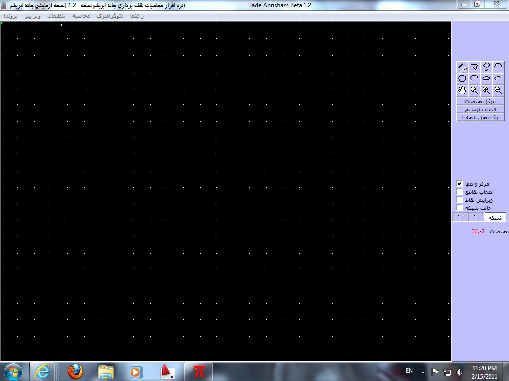
در این میان من یک نرم افزاری که حدودا سه الی چهار سال پیش با عنوان "جاده ابریشم " که یک نرم افزار نقشه برداری محسوب می شود را ساختم .
این نرم یک نرم مستقل بوده " مانند نرم های دیگر ویندوز " که در زمینه مختلف نقشه برداری کاربردهای جزئی دار می باشد.
 |
| بند انگشتی, برای دیدن عکس به صورت کامل بر روی آن کلیک نمایید |
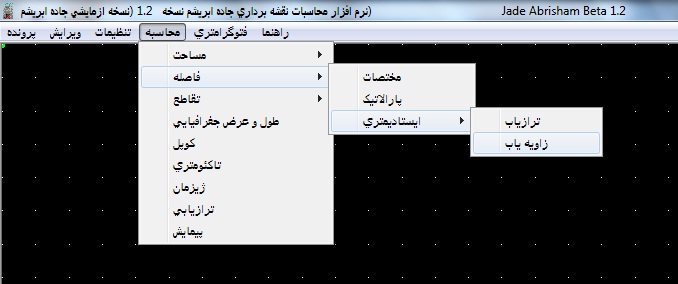
از قابلیت های این نرم افزار می توان به موارد زیر اشاره کرد
تماما فارسی
مشاهده تصاویر رقمی به صورت سه بعدی(در بخش فتوگرامتری)
محاسبه مساحت ومحیط انواع اشکال هندسی
دارای محیط گرافیکی برای ترسیم اشکال
پشتیبانی از
dxf
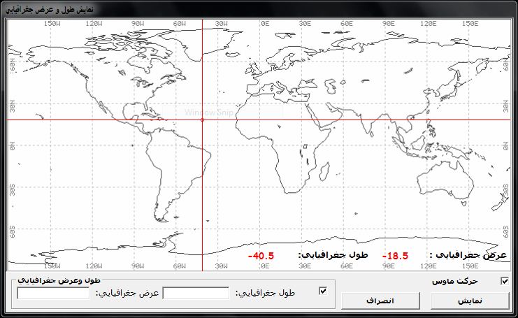
محاسبه طول و عرض جغرافیایی
و غیره
 |
| بند انگشتی, برای دیدن عکس به صورت کامل بر روی آن کلیک نمایید |
 |
| بند انگشتی, برای دیدن عکس به صورت کامل بر روی آن کلیک نمایید |
در حال حاضر یک نسخه ازمایشی از ان ساخته شده .و از همین وبگاه قابل دانلود می باشد . اما به دلیل اینکه یک نفر در توسعه این نرم افزار نقش داشت . به دلیل مشکلات مختلف ( دانش - زمان و .... ) قادر به توسعه آن نگردید . و نرم افزار در حالت آزمایشی باقی مانده است .
 |
| بند انگشتی, برای دیدن عکس به صورت کامل بر روی آن کلیک نمایید |
ما قصد داریم توسعه این نرم افزار را به دست عزیزانی قرار بدهیم که پتانسیل های زیادی دارند . و برا این اعتقاد داریم که یک کار تیمی همیشه بهتر از یک کار تک نفر می باشد . به همین ما سورس کدهای این نرم افزار را در اختیار علاقه مندان به این پروژه قرار خواهیم داد.
دانلود نرم افزار جاده ابریشم
http://www.4shared.com/file/124811119/7d7eb857/Setup.html
موضوع : <-PostCategory->
- نرم افزارهای مهندسی و دیگر رشته ها
- نرم افزار های مهندسی عمران
- نرم افزار های مهندسی مکانیک
- نرم افزار های مهندسی معماری
- نرم افزار های مهندسی نقشه برداری
- نرم افزار های مهندسی معدن
- نرم افزار های مهندسی برق,الکترونیک
- نرم افزار های مهندسی سدسازی
- نرم افزار های مهندسی هوا فضا
- نرم افزار های مهندسی خاک شناسی
- نرم افزار های مهندسی ساخت تولید
- نرم افزار های مهندسی زلزله
- نرم افزار های حسابداری
- نرم افزارهای کاربردی
- نرم افزار مترجم متن
- نرم افزار های مدیریت پروژه
- نرافزار های کاربردی کامپیوتر
- نرم افزار های هک یاهو مسنجر
- نرم افزار های متفاوت مسنجر
- نرم افزار ها و ترفند های هک
- تازه های جهان علم
- تازه های عمران و معماری
- تازه های دنیای کامپیوتر و IT
- پروژه ها
- پروژه بتن
- پروژه فولاد
- پروژه کار آموزی
- پروژه متره براورد
- پروژه بارگذاری
- پروژه راه سازی
- مقالات
- مقالات مهندسی عمران
- مقالات مهندسی معماری
- مقالات مقاوم سازی ساختمان ها
- مقالات مهدسی سدسازی
- مقالات مهندسی هواشناسی
- مقالات مهندسی تاسیسات
- مقالات مهندسی زمین شناسی
- مقالات سازه های بتنی
- مقالات سازه های فلزی
- مجلات تخصصی عمران
- نقشه های سازه ای
- دانلود نقشه
- دانلود نقشه معماری
- دانلود نقشه ساختمان اسکلت فلزی
- دانلود نقشه ساختمان اسکلت بتنی
- آموزش نرم افزارها
- آموزش نرم افزار های مهندسی
- آموزش نرم افزار PLAXIS
- آموزش نرم افزار PERFORM 3D
- آموزش نرم افزار Tekla Structure-Xsteel
- مسائل متفرقه مهندسی
- جزوات درسی
- گزارشکار آزمایشگاه
- آیین نامه ها
- سازه های مهم دنیا
- کارتوگرافی
- معرفی کتاب های فنی مهندسی
- تنش - کرنش
- ماشین الات عمرانی
- سیستم نوین دیوار پیش ساخته
- عمران روستایی
- فرودگاه و مسائل مربوط به آن
- آب بند (Water Stop)
- قالب فلزی و چوبی ( طراحی و ... )
- محاسبه اشکال هندسی با مقاطع
- معرفی چهره های ارزشمند رشته عمران و ...
- جداول مهندسی
- آموزش برنامه نویسی
- زبان تخصصی عمران
- آموزشهای عمومی(کامپیوتر...)
- آثار باستانی و معماری
- مباحث بیست گانه مقررات ملی ساختمان
- بتن اسفجی چیست و چه کاربردهایی دارد؟
- مقاوم سازی لرزه ای ساختمان با استفاده از الیاف پلیمری(FRP)
- بتن سبک یا بتن متخلخل (ھبلکس)
- متافیزیک و علوم غریبه
- نظريه هاي انيشتن(نسبيت عام و خاص)
- همه چیز در مورد پيشگويى هاى نوسترداموس
- بررسی افسانه جزیره خضراء ( مثلث برمودا )
- مطالب متفرقه
- آیا میدانید ؟
- ترفند
- دانلود دفترچه سوالات و کلید کنکور کارشناسی ارشد 90
- عجایب هفتگانه چیست ؟
- آموزش و نت های گیتار
- زندگی نامه بزرگان و دانشمندان
- راهنمای کامل تحصیل در ترکیه
- موسیقی
- دانلود جدیدترین آهنگ ها
- دانلود تمامی فول آلبومهای مازیار فلاحی
- دانلود تمامی فول آلبومهای مرتضی پاشایی
- دانلود تمامی فول آلبومهای محسن یگانه
- دانلود تمامی فول آلبومهای سیاوش قمیشی
- دانلود تمامی فول آلبومهای افشین آذری
- دانلود تمامی فول آلبومهای پویا بیاتی
- دانلود تمامی فول آلبومهای محسن یاحقی
- دانلود تمامی فول آلبومهای علی اصحابی
- دانلود تمامی فول آلبومهای گوگوش + بیوگرافی
- دانلود تمامی فول آلبومهای علی لهراسبی
- دانلود تمامی فول آلبومهای امین رستمی
- دانلود تمامی فول آلبومهای مجید خراطها
- دانلود تمامی فول آلبومهای علی عبدالمالکی
- دانلود تمامی فول آلبومهای رحیم شهریاری
- کد آهنگ پیشواز و خدمات ایرانسل
- اطلاعات و خدمات ايرانسل
- اس ام اس
- اس ام اس ترکی
- اس ام اس ایام مناسبتی
- اس ام اس عاشقانه
- اس ام اس فلسفی
- اس ام اس سرکاری
- اس ام اس امام زمان
- مباحث وب سایت، وبلاگ، اینترنت
- ابزارهای حرفه ای وبلاگ
- Page rank چیست ؟
- سایت های ارائه دهنده قالب وبلاگ
- شش سایت که هر دانشجویی قبل از تحقیق باید ببیند
- سایتی برای ارسال پیامهای کوتاه
- وبلاگی با فضای رایگان بدون محدودیت داشته باشید
- مطالبی در مورد ایمیل
- مینی بلاگینگ
- آشنایی با سیستم مدیریت محتوا Joomla
- معرفی همه ی سایت هایه ارائه sms در ایران
- سرويس هاي گوگل
- هفت سایت ویرایش تصاویر به صورت آنلاین
- هفت سایت ویرایش تصاویر به صورت آنلاین
- 40 وب سایت برای دانلود آیکون های زیبا!
- چگونه بفهمیم دوستمان در یاهو مسنجر (مخفی) است
- معرفی سرویس آپلود رایگان قدرتمند ایرانی
- آموزش آنلاین زبان انگلیسی و آلمانی
- سایت خود را کاملا رایگان ثبت کنید!!!
- آموزش آنلاین زبان انگلیسی و آلمانی
- Meebo سایتی برای چت آنلاین بدون نیاز به مسنجر!!!
- آموزش بهینه سازی سایت و وبلاگ در موتورهای جستجو
- افتتاح سایت فارسی نوکیا
- آموزش وبلاگ نویسی
- ثبت آدرس در موتور جستجوي
- لیست سایتهایی که خدمات رایگان ارائه می دهند
- همه چیز در مورد اینترنت ماهواره ای
- عکس بازیگران زن
- عکس های مهناز افشار
- عکس های مونا فرجاد
- عکس های الهه حصاری
- عکس های فاطمه گودرزی
- عکس های نیوشا ضیغمی
- عکس های نگین خامسی
- عکس های الناز شاکر دوست
- عکس های لیلا اوتادی
- عکس های مریم معصومی
- عکس های سپیده خداوردی
- عکس های الناز حبیبی
- عکس های سیما خضر آبادی
- عکس های فریبا طالبی
- عکس های کیمیا بابائیان
- عکس های سما خانی
- عکس های شبنم قلی خانی
- عکس های نگین خامسی
- عکس های آرام جعفری
- عکس های نگار نیکخواه آزاد
- عکس های آناهیتا نعمتی
- عکس های ماه چهره خلیلی
- عکس های الهام فراهانی
- عکس های جدید آشا محرابی
- عکس های سپند امیرسلیمانی و همسرش
- عکس های بهاره رهنما
- عکس های نرگس محمدی ( ستایش )
- عکسهای آزیتا حاجیان
- عکس های ستاره اسکندری
- عکس های هانیه توسلی
- عکس های لیندا کیانی
- عکس های سامیه لک
- عكس هاي حدیث میرامینی
- عکس های الهام حمیدی
- عکس های گلشيفته فرهاني
- عكس هاي يكتا ناصر
- عکس های روشا ضیغمی
- عکس بازیگران مرد
- عکسهای محمد رضا گلزار
- عکس های داغ ...........................
- بازی گلشیفته فراهانی در اولین سکانس نیمه عریان کارنامه بازیگری اش!
- عکاس رسوا کننده +18
- آنجلیناجولی بر فرش قرمز
- تصاویر - درب جهنم روی زمین
- عکس های زمین خوردن مانکن ها +16
- تصاویر - مانکن های ابتذال روی فرش قرمز
- تصاویر - شایعاتی که همه باور کردند
- تصاویر- مهمانان بدون روسری در ...
- عکسهای خیره کننده از دختران معلق بر روی هوا
- عکس هایی از خارج کردن یک مرد از شکم یک مار بوا
- عکسهای زیبا و دیدنی از مراسم عروسی هیفا وهبی
- دختری 23 ساله با چشمانی عجیب و جادویی +عکس
- عکسهای جنجالی و بی حجاب مهناز افشار در سوئد
- بازیگری که هنوز نیامده با عکسهایش جنجالی شد +عکسها
- عکس های بی حجاب آناهیتا نعمتی در سن دیگو
- دختران تبلیغ کننده ماشین
- عكس هاي مبارزه با بد حجابي 50 عكس
- عکس های متفرقه
- عکس های تاسف انگیز از زن ذلیل ها
- تختخوابهای ابتکاری، زیبا وعجیب وغریب
- عکس های تماشایی از مسابقات بوکس زنان
- تصاویر - رکوردهای جهانی گینس
- تصاویر - چند انیمیشن زیبا و خلاقانه
- تصاویر سه بعدی شگفت انگیز
- راز سالم ماندن اجساد مؤمنین در قبر
- درختان همه چیز را میبلعند!
- تصویری از زندگی مردم کشورهای مختلف
- عکسهای انتخاب دختر شایسته رادیو و تلویزیون روسیه
- مرد بسیار عجیب که بدنش سوراخ نمی شود +عکس
- ازدواج عجیب و باور نکردنی دو دختر با قورباغه! +عکس
- مردی با بزرگ ترین و خنده دار ترین بینی جهان +عکس
- اتفاق عجیبی که برای یک خواننده زن رخ داد +عکس
- دستگیری یک زن به اتهام قتل 30 دختر و خوردن آنها!!
- تصاویر شگفت انگیز یک تمساح بزرگ در فیلیپین
- عکس های نایاب از انفجار بمباتمی
- اسپورت ترین خودروی پیکان در ایران
- عکس هایی از هنر نمایی با دود خفن و جالب و باور نکردنی
- عکس های فانتزی
- عکس های مهندسی و سایر رشته ها
- تصاویر - بزرگترین هتل های جهان
- روستایی در غار(چین)
- مطالب طنز
- داستان کوتاه طنز
- طنز خانوادگی
- طنز دانشجویی
- طنز دخترا
- طنز پسر
- طنز تصویری
- طنز نوشته
- طنز ورزشي
- مطالب جالب و آموزنده
- طنز فرهنگی
- مطالب عاشقانه
- شعر زیبای خیانت + عکس
- جملات قصار و کوتاه عاشقانه
- قطعات عاشقانه
- مطالب عاشقانه
- ترانه های عاشقانه
- نامه های عاشقانه
- داستان های عاشقانه
- اخبار داغ باشگاه تراختور
- عکس هواداران تراختور ( مرد، زن ، دختر، پسر، پیر، جوان )
- لوازم و ابزار جاسوسی
- همه چیز در مورد شیطان پرستان
- مطالب خیلی خیلی جالب
طراحی وب
پرشین گرافیک
- نیمه ی گمشده (رویا)
- جدیدترین رمزهای NOD32
- سرگرم کننده
- مهندس عمران
- عشق عاشقی کشکه... بیا تو
- یه دختر سرخوش
- دنیای کوچک من
- از شیر مرغ تا جون آدمیزاد
- عاشقی جرم قشنگیست به انکارش مکوش
- آموزش جامع مسائل جنسی
- یادداشت های دخترانه
- شعر و ترانه
- everything
- دانلود و فروشگاه
- کیت اگزوز
- زنون قوی
- چراغ لیزری دوچرخه
![]() تبادل
لینک هوشمند
تبادل
لینک هوشمند
![]()
برای تبادل
لینک ابتدا ما
را با عنوان
سایت علمی و تفریحی
و آدرس
www.civilbax.loxblog.com
لینک
نمایید سپس
مشخصات لینک
خود را در زیر
نوشته . در صورت
وجود لینک ما در
سایت شما
لینکتان به طور
خودکار در سایت
ما قرار میگیرد.


|
||
|
|
||
|
|
||

